Challenges of Phenology – based Global Land Cover Classification ー Research collaboration between Kyoto University and University of Leicester ー
Project Gist
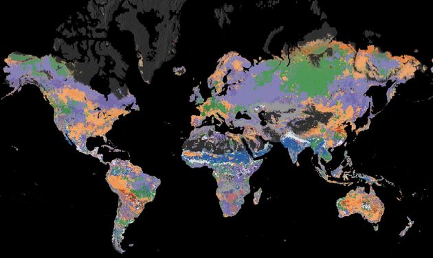
Land surface phenology classification mapping
Keywords
Phenology, Land cover, Remote sensing
Background and Purpose
Land surface phenology, spatio-temporal characteristics of the vegetated land surface monitored by satellite sensors, is often considered as a proxy of ground-based phenology. The land surface phenology which interacts with climate factors geographically is considered as an indicator of climate changes. However, there has been few studies of understandings of the global pattern of land surface phenology. The objective of this project is therefore to produce global phenological classification map for describing geographic and environmental characteristics.
Project Achievements
We made annual phenological classification maps at a global scale during the period from 2002 to 2016 for the first time. Through this project, 4 research meetings, 2 workshops, and 1 conferences have been held. These expanded research networks successfully. One of outstanding achievement was to hold the international session “Mapping phenology with remote sensing” in JpGU (Japan Geoscience Union) annual meeting in 2017 organized by this project members.
Future Prospects
A future challenge is to identify interactions amongst phenological changes, climate changes, and anthropogenic impacts on the earth. We also would like to develop local-scale researches in which global-scale studies suggest outstanding local behaviors.
Figure
Principal Investigator

・TSUTSUMIDA Narumasa
・Graduate School of Global Environmental Studies
・He awarded Doctor degree of Global Environmental Studies in 2014. His research theme is land cover monitoring for regional planning by GIScience approach. He has conducted urban expansion monitoring, global land cover change, phenology dynamics, and accuracy assessment of spatial data.
・http://www2.ges.kyoto-u.ac.jp/members/tsutsumida-narumasa/